Plum Pox Virus Infested Place Order, 2014
This page is part of the Guidance Document Repository (GDR).
Looking for related documents?
Search for related documents in the Guidance Document Repository
The Minister of Agriculture and Agri-Food, pursuant to subsection 15(3) of the Plant Protection ActFootnote 1, hereby makes the annexed Plum Pox Virus Infested Place Order, 2014.
Ottawa, Ontario, 14 March, 2014
Interpretation
1. In this Order,
"infested place" means the place set out in Schedule I; (lieu infesté)
"inspector" means a person designated as an inspector pursuant to section 21 of the Plant Protection Act and under section 13 of the Canadian Food Inspection Agency Act; (inspecteur)
"pest" means the plum pox virus; (parasite) and
"plant" means a plant of any species of Prunus, other than a species of Prunus listed in Schedule II, including any part of such plant other than fresh fruit or dead or dried out branches and logs of plants. (végétal)
Declaration
2. It is hereby declared that the place set out in Schedule I is infested with the plum pox virus.
Movement Out of the Infested Place
3. No person, except an inspector, shall move or cause movement of the pest or a plant out of the infested place, unless authorized to do so beforehand in writing by an inspector and unless the person complies with the authorization.
Repeal
4. The Plum Pox Virus Infested Places Order made on March 13, 2008 is repealed.
Schedule I
(Infested Place)
For the purposes of this Order, the infested place is comprised of the following areas:
- All that part of the City of Hamilton of Ontario, as depicted in Map 1 attached hereto, and as more particularly described as follows:
Commencing at a point of intersection of the municipal boundary line between the city of Hamilton and the Town of Grimsby and Smith Road;
Thence proceeding westwardly along the north side of Smith Road to 11th Road East;
Thence proceeding northwardly along the east side of 11th Road East continuing northwardly, westwardly, eastwardly, northwardly, westwardly and northwardly along the east, north, south, east, north and east side of Fifty Road, extended through by a straight line to the shores of Lake Ontario;
Thence proceeding eastwardly along the shoreline of Lake Ontario to the municipal boundary line between the City of Hamilton and the Town of Grimsby;
Thence proceeding southwardly along the west side of the municipal boundary line between the City of Hamilton and the Town of Grimbsy to the point of commencement.
- All that part of the Town of Pelham in the Province of Ontario, as depicted in Map 2 attached hereto, and as more particularly described as follows:
Commencing at a point of intersection of the municipal boundary line between the Town of Lincoln and the Town of Pelham and Twenty Road;
Thence proceeding southwestwardly along the south side of Twenty Road to Maple Street;
Thence proceeding southwardly along the east side of Maple Street to Sawmill Road; Thence proceeding eastwardly along the north side of Sawmill Road to Center Street;
Thence proceeding northwardly along the west side of the Center Street to municipal boundary line between the Town of Lincoln and the Town of Pelham;
Thence proceeding westwardly along the municipal boundary line between the Town of Lincoln and the Town of Pelham to the point of commencement.
- All that part of the City of Thorold in the Province of Ontario, as depicted in Map 3 attached hereto, and as more particularly described as follows:
Commencing at a point of intersection of the municipal boundary line between the City of Thorold and City of St. Catharines and Decew Road;
Thence proceeding eastwardly along the north side of Decew Road to Beaverdams Road;
Thence proceeding northeastwardly along the north side of Beaverdams Road to Marlatts Road;
Thence proceeding eastwardly along the north side of Marlatts Road extended through by a straight line to the intersection of Niagara Falls Road and Allanburg Road;
Thence proceeding eastwardly along the north side of Niagara Falls Road to Beaverdams Road;
Thence proceeding eastwardly along the north side of Beaverdams Road to the municipal boundary between the City of Thorold and the City of Niagara Falls;
Thence proceeding northwardly along the municipal boundary line between the City of Thorold and the City of Niagara Falls to the municipal boundary line between the City of Thorold and the Town of Niagara-on-the-Lake;
Thence proceeding southwestwardly along the boundary line between the City of Thorold and the Town of Niagara-on-the-Lake to the municipal boundary between the Town of Niagara-on-the-Lake and City of St. Catharines;
Thence proceeding southwestwardly along the boundary line between the City of Thorold and the City of St. Catharines to the point of commencement.
- All that part of the City of Niagara Falls in the Province of Ontario, as depicted in Map 4 attached hereto, and as more particularly described as follows:
Commencing at the point of intersection between Niagara Townline Road and Stanley Avenue;
Thence proceeding southwardly along the west side Stanley Avenue to Portage Road;
Thence proceeding southwestwardly along the north side of Portage Road to Mountain Road;
Thence proceeding westwardly along the north side of Mountain Road to Mewburn Road;
Thence proceeding northwardly, westwardly and northwardly along the east, north and east sides of Mewburn Road to the municipal boundary line between of the Town of Niagara-on-the-Lake and the City of Niagara Falls; and
Thence proceeding eastwardly along the municipal boundary line between the Town of Niagara-on-the Lake and the City of Niagara Falls to the point of commencement.
- The entire Town of Grimsby in the Province of Ontario, as depicted in Map 5 attached hereto.
- The entire Town of Lincoln in the Province of Ontario, as depicted in Map 5 attached hereto.
- The entire City of St. Catharines in the Province of Ontario, as depicted in Map 5 attached hereto.
- The entire Town of Niagara-on-the-Lake in the Province of Ontario, as depicted in Map 5 attached hereto.
Click on image for larger view
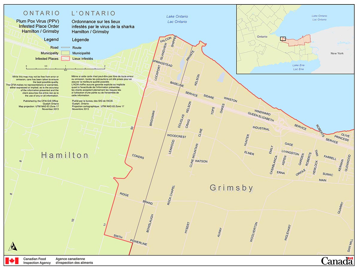
Description for Map 1 - The City of Hamilton Area (part of the Niagara PPV Infested Place)
This image is a map that shows the City of Hamilton Plum Pox Virus Infested Place (part of the Niagara Plum Pox Virus Infested Place). The infested place includes:
- Commencing at a point of intersection of the municipal boundary line between the city of Hamilton and the Town of Grimsby and Smith Road;
- Thence proceeding westwardly along the north side of Smith Road to 11th Road East;
- Thence proceeding northwardly along the east side of 11th Road East continuing northwardly, westwardly, eastwardly, northwardly, westwardly and northwardly along the east, north, south, east, north and east side of Fifty Road, extended through by a straight line to the shores of Lake Ontario;
- Thence proceeding eastwardly along the shoreline of Lake Ontario to the municipal boundary line between the City of Hamilton and the Town of Grimsby;
- Thence proceeding southwardly along the west side of the municipal boundary line between the City of Hamilton and the Town of Grimbsy to the point of commencement.
Click on image for larger view
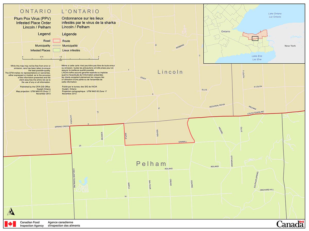
Description of the Plum Pox Virus Infested Place Order, 2014 - Map 2
This image is a map that shows the Town of Pelham Plum Pox Virus Infested Place (part of the Niagara Plum Pox Virus Infested Place). The infested place includes:
- Commencing at a point of intersection of the municipal boundary line between the Town of Lincoln and the Town of Pelham and Twenty Road;
- Thence proceeding southwestwardly along the south side of Twenty Road to Maple Street;
- Thence proceeding southwardly along the east side of Maple Street to Sawmill Road;
- Thence proceeding eastwardly along the north side of Sawmill Road to Center Street;
- Thence proceeding northwardly along the west side of the Center Street to municipal boundary line between the Town of Lincoln and the Town of Pelham;
- Thence proceeding westwardly along the municipal boundary line between the Town of Lincoln and the Town of Pelham to the point of commencement.
Click on image for larger view
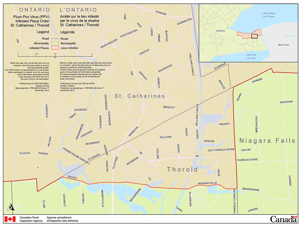
Description of the Plum Pox Virus Infested Place Order, 2014 - Map 3
This image is a map that shows the City of Thorold Plum Pox virus Infested Place (part of the Niagara Plum Pox Virus Infested Place). The infested place includes:
- Commencing at a point of intersection of the municipal boundary line between the City of Thorold and City of St. Catharines and Decew Road;
- Thence proceeding eastwardly along the north side of Decew Road to Beaverdams Road;
- Thence proceeding northeastwardly along the north side of Beaverdams Road to Marlatts Road;
- Thence proceeding eastwardly along the north side of Marlatts Road extended through by a straight line to the intersection of Niagara Falls Road and Allanburg Road;
- Thence proceeding eastwardly along the north side of Niagara Falls Road to Beaverdams Road;
- Thence proceeding eastwardly along the north side of Beaverdams Road to the municipal boundary between the City of Thorold and the City of Niagara Falls;
- Thence proceeding northwardly along the municipal boundary line between the City of Thorold and the City of Niagara Falls to the municipal boundary line between the City of Thorold and the Town of Niagara-on-the-Lake;
- Thence proceeding southwestwardly along the boundary line between the City of Thorold and the Town of Niagara-on-the-Lake to the municipal boundary between the Town of Niagara-on-the-Lake and City of St. Catharines;
- Thence proceeding southwestwardly along the boundary line between the City of Thorold and the City of St. Catharines to the point of commencement.
Click on image for larger view
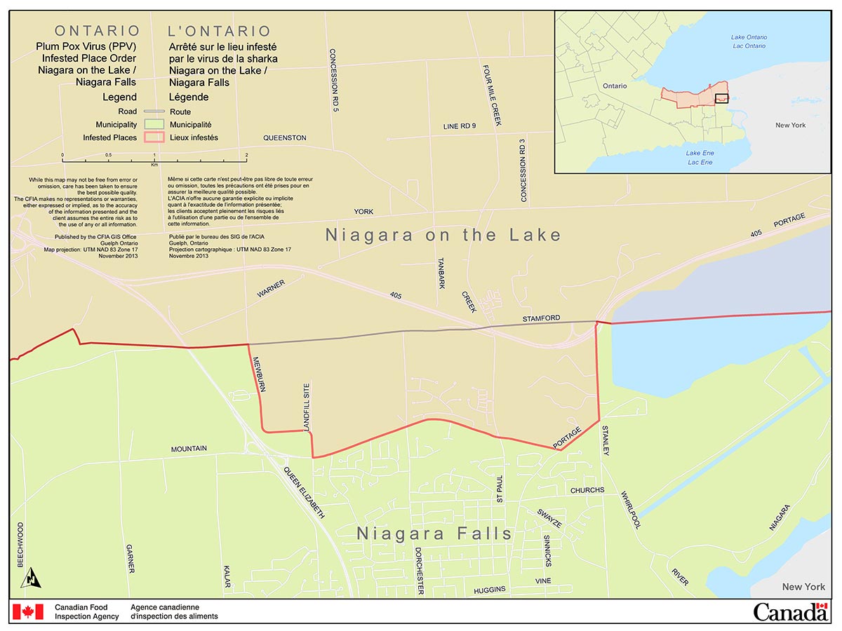
Description of the Plum Pox Virus Infested Place Order, 2014 - Map 4
This image is a map that shows the City of Niagara Falls Plum Pox Virus Infested Place (part of the Niagara Plum Pox Virus Infested Place). The infested place includes:
- Commencing at the point of intersection between Niagara Townline Road and Stanley Avenue;
- Thence proceeding southwardly along the west side Stanley Avenue to Portage Road;
- Thence proceeding southwestwardly along the north side of Portage Road to Mountain Road;
- Thence proceeding westwardly along the north side of Mountain Road to Mewburn Road;
- Thence proceeding northwardly, westwardly and northwardly along the east, north and east sides of Mewburn Road to the municipal boundary line between of the Town of Niagara-on-the-Lake and the City of Niagara Falls; and
- Thence proceeding eastwardly along the municipal boundary line between the Town of Niagara-on-the Lake and the City of Niagara Falls to the point of commencement.
Click on image for larger view
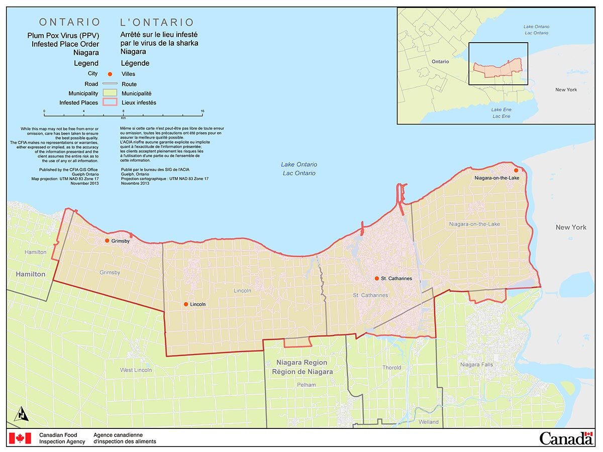
Description of the Plum Pox Virus Infested Place Order, 2014 - Map 5
This image is a map that shows the Niagara Plum Pox Infested Place consisting of the entire Town of Grimsby, the entire Town of Lincoln, the entire City of St. Catharines, the entire Town of Niagara-on-the-Lake and designated sections of and designated sections of the City of Hamilton, Town of Pelham, City of Thorold, and City of Niagara Falls.
Schedule II
(Excepted Prunus)
P. alabamensis
P. apetala
P. avium
P. buergeriana
P. campanulata
P. canescens
P. caroliniana
P. cerasoides
P. cerasus
P. changyangensis
P. conadenia
P. concinna
P. cornuta
P. cyclamina
P. dawychensis
P. dielsiana
P. effusa
P. emarginata
P. eminens
P. fontanesiana
P. fruticosa
P. gonduinii
P. grayana
P. hillieri
P. hirtipes
P. ilicifolia
P. incisa
P. juddii
P. kurilensis
P. laucheana
P. laurocerasus
P. litigiosa
P. lusitanica
P. lyonii
P. maackii
P. macradenia
P. mahaleb
P. maximowiczii
P. mugus
P. nipponica
P. padus
P. pensylvanica
P. pilosiuscula
P. pleiocerasus
P. pseudocerasus
P. rufa
P. sargentii
P. schmittii
P. sericea
P. serotina
P. serrula
P. serrulata
P. setulosa
P. speciosa
P. spinulosa
P. ssiori
P. subhirtella
P. tatsienensis
P. vaniotii
P. virens
P. virginiana
P. wallichii
P. wilsonii
P. yedoensis
P. zippeliana
- Date modified: