
Outbreak Investigation Report on Avian Influenza in British Columbia, 2014
1. The Fraser Valley of British Columbia - Outbreak Context
1.1. Geography and Climate
The Fraser Valley is a fertile floodplain that follows the Fraser River through the Pacific Coast Mountain Ranges from Abbotsford and Mission eastward to Hope. It is one of the most diverse and intensively farmed areas in Canada. The climate of the Fraser Valley attracts many species of wild resident and migratory waterfowl and shorebirds (eBird Canada). The Fraser Valley lies within the Pacific Flyway (Figure 1), which extends from the western Arctic through the Rocky Mountain and Pacific Coast regions of Canada, the United States and Mexico, south to where it blends with other flyways in Central and South America.
The Fraser Valley normally experiences heavy seasonal rainfall in November. In 2014, Abbotsford received 232.5 mm total precipitation with a mean monthly temperature of 6°C. Most (over 67%) of the precipitation fell as rain over eight days from the 20th to the 28th, During which period there was an average daily rainfall of over 17 mm and a mean daily temperature of 7°C. As a result, there were reports of increased standing water on farms. This rainy period was immediately followed by colder temperatures of -4.6 and -4.7°C on November 29th and 30th and no measurable precipitation until December 3rd. Then there were six days that saw 90 mm of rain and a mean daily temperature of 9.5°C. Overall, the month of December 2014 experienced higher than normal average temperatures (5.1°C) and precipitation (214.2 mm).
Figure 1: The Pacific Flyway (Texas Parks and Wildlife Department)
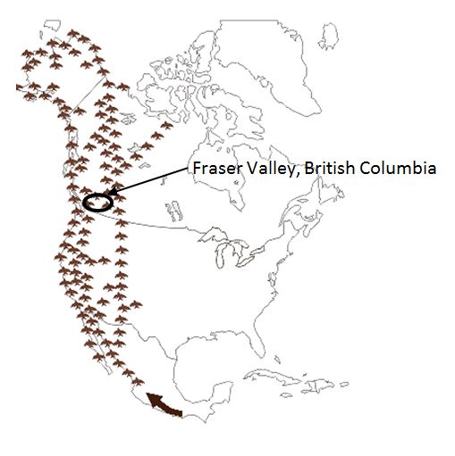
Description for photo - The Pacific Flyway
This map shows the south to north path of the Pacific Flyway through North America. The Fraser Valley of British Columbia is located in the flyway. The bird migration route extends from Alaska to Patagonia and follows the west coast of North America with incursions into Western States of the United States, covering all of British Columbia and extending to the Northwest Territories and Nunavut in Canada in northwestern Canada.
1.2. Structure of the Poultry Industry
The commercial poultry industry in BC is highly integrated. Each sector is represented by a separate organization, and there are marketing boards for broiler chickens, commercial turkeys, table eggs, and hatching eggs. These groups work together to address biosecurity issues, establish premises identification programs, and motivate producers to cooperate with disease surveillance and control programs. Outside the supply-managed sectors, other smaller sectors include layer breeders, ducks, geese, squab, pheasant, quail, and specialty chickens. In addition to the commodity specific groups, the BC Poultry Association (BCPA) is a joint producer association comprised of representatives from each sector.
The non-commercial poultry sector in the Fraser Valley is diverse and individual production systems are unique. There is no mandatory registry for the non-commercial poultry sector.
The poultry sector is economically important to BC, with farm production sales of $632 million in 2013. There are approximately 850 regulated commercial poultry producers in British Columbia. Eighty percent of production occurs in the Fraser Valley.
1.3. Biosecurity
The BCPA has taken an active role in the development and implementation of a biosecurity program. In December 2008, the BC Biosecurity Program became mandatory for all commercial poultry operations in the province. All regulated farms are audited for compliance.
A Self-Assessment Tool and Biosecurity Guide were created by industry and government partners for non-commercial poultry producers to increase biosecurity awareness; facilitate identification of biosecurity risks and encourage implementation of enhanced biosecurity protocols. In response to the 2014 outbreak, the BC Ministry of Agriculture (BCMAGRI) organized town hall meetings and conference calls for small flock and specialty bird producers to raise awareness about biosecurity.
1.4. Premises Identification
All regulated commercial poultry operations have been geo-referenced and a database is available to assist the CFIA to locate poultry farms during an outbreak response. All commercial poultry farms in BC have a unique alpha-numeric Premises ID, assigned and managed by the BCMAGRI. Premises IDs are posted on bright orange signs at the entrance of each farm and designated sub-premises numbers are attached to each barn.
- Date modified: